Through New Mexico; an end to the Divide

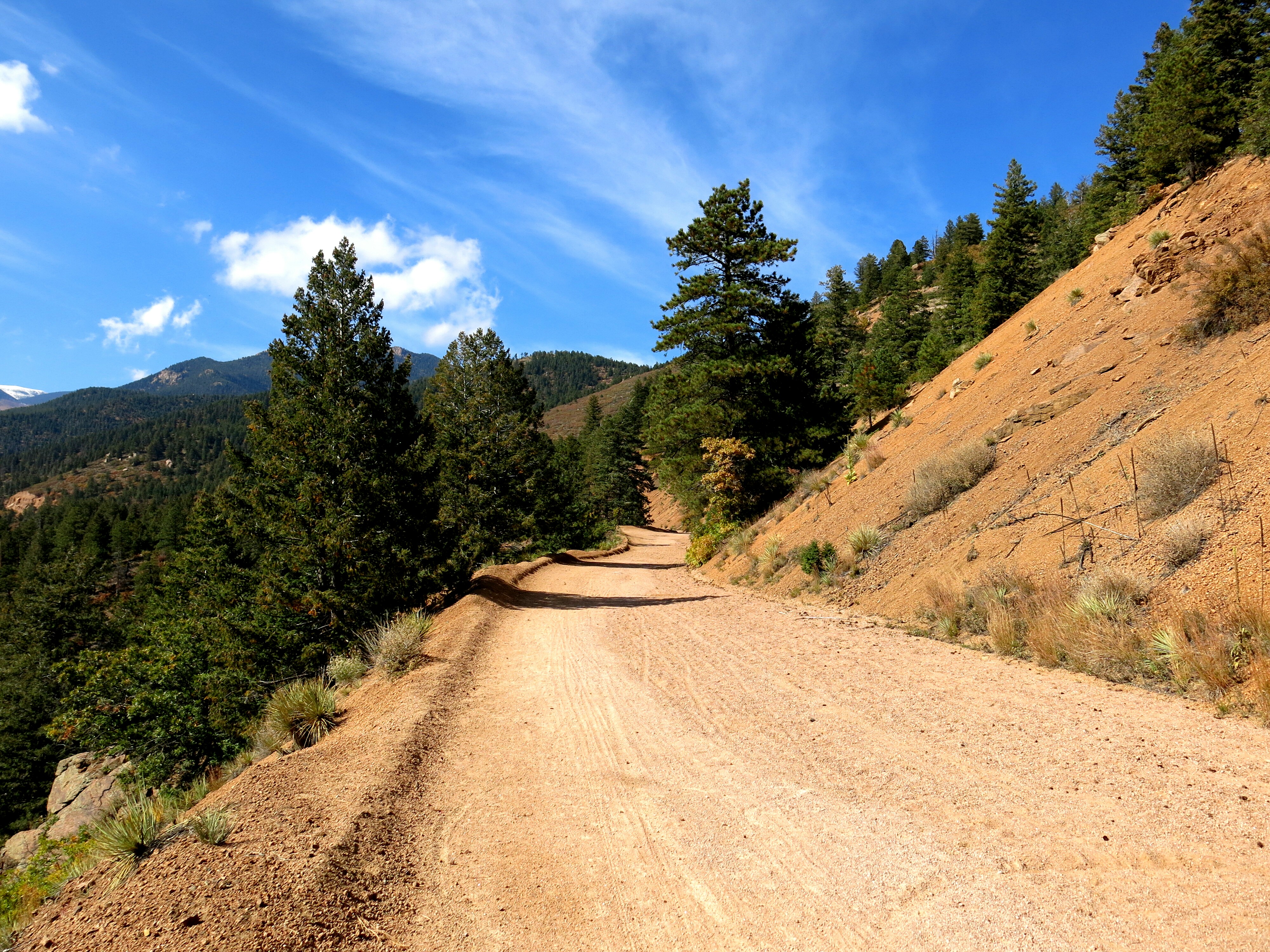
From the high mountains to tacky mud and rocky mesas. The Southwest provides a change in scenery.

image

The change from trees to rocks happens nearly right after crossing the Colorado border.

image

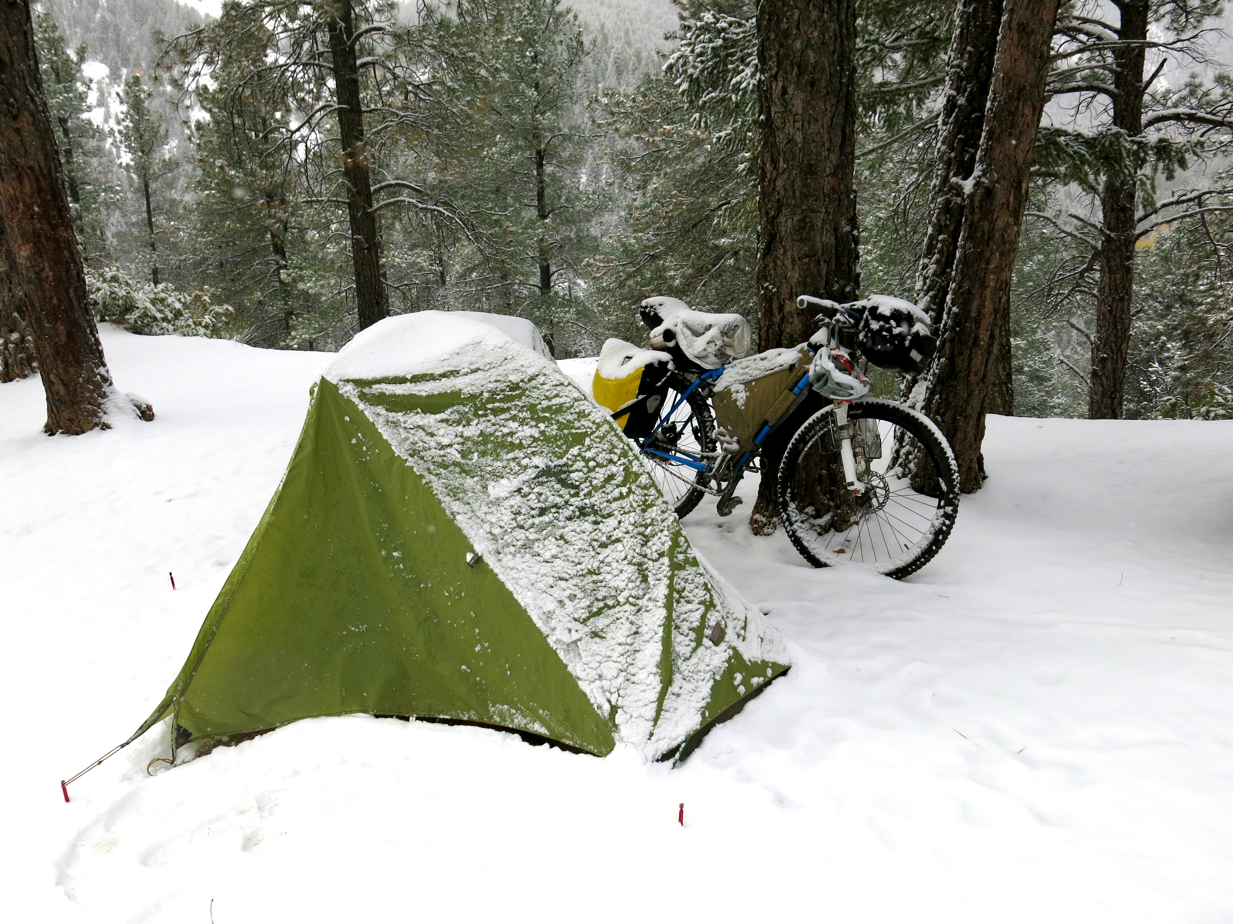
The warnings in the Divide maps for New Mexico are all about rain, which apparently changes the dirt here into an impenetrable mud. Storms brewing diverted me to a lot of road alternates for this section of the Divide, which ultimately worked out well. Here I pitched my tent for the night with Kirk, who has been hiking his way south from the Canadian border in June along the Continental Divide Trail. The CDT sticks as close to the Continental Divide as possible, whereas the Great Divide biking route sticks more to dirt roads that parallel the Divide. Kirk would be the first of the CDT hikers I got to meet, for while there aren’t many bikers riding the Divide this late in the year, November is apparently when many of the southbound CDT hikers get to New Mexico. Fun group of people, and interesting to see some of the differences between long-distance hikers and bikers. I think we both raised our eyebrows at each others’ paces.

image

Goats in Abiquiu, where I got to spend a day resting with Santana’s family.

image

And a backroads route away from their home, getting in a dirt fix.

image

Mostly firm dirt or slick rocks, with a few patches of sand mixed in. Good riding.

image

Abiquiu Dam, one of the only pockets of surface water I saw in New Mexico. Thankfully it wasn’t too hot, or carrying a lot more water would have been necessary.

image

And in Cuba I got to stay with more family. What luck, and thanks to all! Chopped up plenty of wood with Eddy to keep the house warm through the upcoming storm.

image

On the road from Cuba to Grants, amidst an ever-changing sky.

image

Mesas, jutting out one after the other, providing relief from an otherwise flattish landscape.

image

When the road turns to sand, wider tires are better. Here I probably should have let more air out to make the going easier.

image

The area is also known for old lava flows that have hardened and are now used as waking paths.

image

Heading for Pie Town, my final destination on the Divide. Getting close. Pie Town is home to two cafes renowned for their pie, of course. Legend has it the town was started when an entrepreneur found out a highway was coming through the area, and decided to sell pies to the travelers coming through. Now there’s a huge festival dedicated to the pies earlier in the fall, but a well-connected community lives there the rest of the year. One woman, Nita, leaves a house open for all the bikers and hikers coming through, making the town a great meeting and resting place. The pie certainly helps, too.

image

If you ever needed a reminder that this is still the West…

image

Made it!

image

Sampling the delights at the Pie-O-Neer Cafe. A slice of cherry to start…

image

Followed by a piece of New Mexican apple. Apples cut up with pine nuts and green chile, for a little kick. Would definitely have been a good one to have a la mode.

image

Nita’s house is called the Toaster House, and anyone in town can give you directions to it. With beds, a kitchen, showers, laundry, and food in the fridge, I think we all ended up staying a day longer than we planned. Four CDT hikers were enjoying a day off when I arrived, and another arrived the following day with word of 3-4 others a day behind him. The hikers are very organized, to the point where they shipped all (or at least most) of their food supplies ahead at the start of the trip and pick them up whenever they get to a town. Luckily for me, many were progressing through New Mexico faster than expected, so they had a lot of extra food they didn’t need. I’m now trying some of their homemade dehydrated foods (rice and beans or Tuna fish casserole anyone?) for my camp dinners.

image

In front of the Toaster House, saying goodbye to a fun town in a unique state.

Leaving Colorado

After a month and a half of freezing nights, it was almost a shock to get to New Mexico and pitch the tent in a rainstorm rather than snow. How warm it must be! But leaving Colorado was enough of a roller-coaster ride up and down one pass after another that riding down onto the New Mexican plateaus was a nice change.

IMG_5355[1]

Some snapshots of the ride:

Leaving Mantiou Springs, the plan was to ride Forest Service roads through the Pike National Forest to Canon City, then head down to Westcliffe and from there cross over the Sangre de Cristo mountains, at which point I’d be on Hwy 160 in the San Luis Valley. The Valley is a pretty flat high altitude basin, promising a quick ride to Del Norte, where I could reconnect with the Divide. But some parts of this plan were destined to change.

IMG_20131027_115329There’s lot of evidence of flood damage around Manitou. This road, just outside of Colorado Springs, was officially closed due to a portion of it washing away. Local hikers and mountain bikers were taking advantage of it being car-free, though. Roads and skies were looking good, so I pressed on.

IMG_20131027_115556And then the next morning woke up to this. Considering that there were 2-3inches of snow with more still falling, and that I was only at 7500ft, continuing on the mapped out trail to 9500ft didn’t seem like such a great idea. Maybe with a fatbike… Instead, I backtracked to Colorado Springs and took the highway south to Canon City. Down at 6000ft, the ground was clear.

IMG_5297[1]

From Cañon City, I got back on the planned route to Westcliffe, where after a particularly cold night in the city park I met Jewel, Pierre, and Alex in the hopping Have A Nice Day Cafe the next morning. They knew about a legendary local castle nearby and were going to check it out, and took me along for the ride.

IMG_5307[1]

Joe Bishop’s Castle. Building started in 1969 and is still going, all work done by one man, Joe Bishop. At the beginning, the castle was on National Forest land. After a while and a few wild parties and court fights, Colorado decided they didn’t want liability for the castle and sold Joe Bishop the land the castle was on, for very cheap. The castle is an impressive monument to one man’s vision and dedication; structural-integrity wise, it could’ve used more-lots more-planning. But a cool site to walk around.

IMG_20131027_120008[1]Home on the range.

IMG_5312[1]

Back on the bike, time to go over the Sangre de Cristo mountain range back to western Colorado. Two more days of riding to get through the San Luis Valley, then back on the trail at Del Norte.

IMG_5334[1]

Just out of Del Norte lies the start to perhaps the longest climb (4000′) to the highest point on the Great Divide route, Indiana Pass, at 11,910′. The turn-off to Platoro, a few miles down the trail, was covered in snow and mud, so I missed it. After descending for a few miles and realizing my mistake, I took what was left of the afternoon to make my way back up to the last trail marker to find the right way.

IMG_5337[1]

The snow does not make the Divide impassable this time of the year, but up in the mountains, there are some shaded portions of the road that never see sunlight. These spots stay snow-covered and frozen, making it harder to find a spot to set up the tent.

IMG_20131026_231932[1]But not impossible. As long as you’re willing to brave leaving the warm embrace of your sleeping bag in the morning, the colors of snow-covered landscapes easily justify riding at this time of the year.

IMG_20131027_120059[1]

IMG_20131027_115806[1]Colorful Colorado indeed.

IMG_20131027_120314[1]The road to Platoro, a town of maybe 20-30 homes, but with a cafe or two for vacationers. One cafe had already closed for winter, and the other was in the process of being cleaned and organized to close in two more days. I got a sandwich and a Coke and rode on, spurred by reports of another storm coming in that night. After Platoro, I crossed into New Mexico above Chama, and right away warmed up with a quesadilla filled with the famed New Mexican green chili. Colorado was a great state, and I’m looking forward to going back sometime.

Other highlights, from off the bike:

IMG_20131027_114916[1]Pikes Peak looming over Manitou Springs; having this mountain in constant view was a good reminder of what lay ahead. Also, the Incline path, carved out just to the right of center in the trees, was a good off’bike workout. Thanks Sukie and Bob for showing me around!

IMG_20131027_114727[1]Garden of the Gods, full of stunning red rock to explore.

IMG_20131016_223332[1]A quick jaunt (Ace stayed in Manitou for the day) up to Denver for a cousin visit. Good to see you guys again, Stuart and Leah!

IMG_20131010_195524[1]Goodbye to the high passes, for a while.

IMG_20131010_210058[1]Autumn colors all around.

IMG_20131010_195335[1]Quiet campsite in the woods.

Update: In New Mexico

Here’s what’s been happening lately. I’m trying to escape this:

image

And now I’m here:

image

I’m back on the Divide, for now, after saying goodbye to Virgile and Marion and then heading to Manitou Springs for a week to rest and relax. It was a great week, with warm and casting hosts. Thank you, Tanabes. I’m consolidating photos and working on posts, but for now am headed full speed to Phoenix, looking forward to warmth and friends. There have been many adventures since Fraser, but the short days and incessant, remote passes crossed to leave Colorado aren’t allowing much internet time. Planning to be Phoenix by the first week of November, so more updates coming then.

Steamboat Springs, CO to Fraser, CO.

After getting through the snowstorm, Virgile, Marion, and I are working our way through Colorado, though the threat of another storm coming led us to take a break in Fraser,CO for a few days to wait it out.

image
After the first storm, we left Steamboat Lake for the much bigger town of Steamboat Springs, where we were wonderfully put up for a few days by Hugh, Jim, and Joan. This town has everything I imagine about a Colorado town; bikes everywhere, active people, and mountains in and around town for biking, hiking, skiing. Our first order of business when we arrived was finding a good burger place. The Double Z didn’t disappoint! My first time eating out about a month!

image
Steamboat Springs is a town of titanium. Moots, a company known worldwide for its titanium bikes, has its factory here, with tours on Mon/Wed/Fri at 10am. Our hosts were friends with Kent Erikson, the founder of Moots, who sold the company some years ago and now has his own custom frame-building business in town. He and his workers are super chill and showed us around his shop. Gorgeous bikes.

image
With Kent and the workers. Super chill, making awesome bikes.

image
After a few days’ rest and catching up on our digital work, it was back on the road. Right away we’re back to climbing, though luckily our rest had given the roads some time to dry after the snow.

image
At the top of Lynx Pass. A decent climb to get here, though I had gotten confused by one of the signs earlier and thought we still had 10km to go to the top. Luckily Virgile and Marion corrected me, leading to smiles all around.

image
Our campsite for the night.

image
The next day we had a little farther to go through the forests, featuring steep climbs that we weren’t at all expecting. But we had promise of reaching the Colorado River to lure us on.

image
Biking, through trees and under warm sun.

image
Our map for today kept talking about the long dive to the Colorado. Here we’re finally at the start of the dive, after many false expectations that we’d already started the descent. Here at the top of the canyon though, we had great views of the valley where we’re headed.

image
Marion on the descent. Despite getting closer to the Colorado, the landscape is dusty and dry. A huge old tree right by the river gave us shade for lunch.

image
River valley in the background.

image
After climbing back out of the valley and down the other side to Kremmling, we took a tiny detour off the Great Divide to head to Fraser, as word was there was another storm coming Thursday night. Some relatives offered us use of their condo in Fraser, which turned out to be the perfect place and timing to stay warm while the snow fell.

image
We took advantage of having an actual kitchen to use, cooking food from home instead of the pasta and rice and instant mashed potatoes dishes that have become our staples.

image
Bread, salads, chicken and potatoes, pizza. We ate well.

Thanks Uncle John and Aunt Mary Beth for the place to stay! It’s time to head south again, since supposedly our next destination is Colorado’s “banana belt”, with at least slightly warmer temperatures than here.

Campsite.

Campsite; tents pitched, bikes sprawled on the ground. Pots and bags of food out and about, food still the main focus of all cyclists. We’re not in bear country tonight so we’re lazy putting food away, though we still sleep with the bear spray handy out of habit. We had a fire tonight, a celebration of people sharing a common destination and community. Friendship? It’s a fun night, filming dinner, laughter. As the sun goes down the short sleeve shirts that are helping cement those tan lines get supplemented with a long-sleeve layer, then the down jackets, a beanie. We roast sausages in the fire, and marshmallows afterward. One by one we retreat to our tents. Time to read, to write, to rest and recover. Expecting it to freeze tonight, might be a bit chilly in the tents, but no matter, we sleep soundly and look forward to tomorrow. Full moon tonight, shining bright. Sleep well.

image
Photo courtesy Pignon Voyageurs.

Biking.

The road ahead is empty save for the trees. Dirt road, gravel, pavement, doesn’t matter. Swing the right leg over the saddle, put the left foot up on the pedal, push off and start going. This is the movement getting ingrained in muscle memory. It felt natural before, but now it’s even more familiar, happens without thinking. On the bike is where I belong; sometimes I don’t know where I fit in elsewhere, but here, on the saddle, legs pumping up and down, there’s no judgment, just movement. Riding, one kilometer at a time.

image

Day 80. First full day in Colorado, crossing the watershed divide to Steamboat Lake.

Got snow during the night. Didn’t look too bad when we woke, still snowing a bit, eat breakfast in the tent. It’s cold this morning, but the coffee is warm. Sit around in the tent a little while longer, get packed up, go. Starts snowing a little harder right as we start leaving. Beautiful as we start the climb, snow is falling, check biking through snow off the list, there’s snow hanging in the trees on the side of the road. Perfect. It’s cold but we’re warm from climbing. Soon road gets too rocky, can’t ride anymore, have to push the bikes. Seatstay bridge is wide enough to grab hold of to pull the bike uphill. Helps when pushing the handlebars is too hard to get traction. There are a couple of fallen trees blocking the road, have to forge a way through the forest around them, one, two, three, four in rapid succession. Keep climbing. There are a few sections that are ridable but they last seconds, end up sliding back and forth in the mud, so back to walking. We push the bikes for the last 2-3kms. Snow’s falling more heavily at the top, blanketing everything, can’t even see the two tracks left by cars, following a blank space between trees and hoping that’s the road. Miss the right turn at the top that starts the descent, Virgile talks to two hunters parked up there, they point us the right way. No good when the road is unsigned. Descent down is hard. 10km, pushing the bike for all but the last 2, freezing, don’t have the exertion of the climb to stay warm anymore. Hands aren’t numb but close, wearing the rain gloves, Marion wearing my warmer set. Tired at that point too, and hungry, really should have had something easy to eat at the pass. Descent becomes frustrating, just low on energy, everything becomes annoying, cold always, just have to get down, no other option. Everything at the top covered in snow, the portions that are clear farther down are only visible because of water running over them, no good break points. Eventually get to the bottom, maybe two hours later, head to Steamboat Lake, some hunters we passed said there’s a place to camp and get coffee there. We arrive, there’s a building with a laundromat and tables to sit and eat, it’s warm, perfect. We huddle inside, perfect shelter, start stripping off wet clothes, grab all our merino off the bikes. There are hot showers next door, too warm, almost shocking contrast to the last five or six hours. But oh so nice. We make coffee and a big pot of rice and zucchini and sausage for lunch, this after eating nearly all our cookies. Dates turn out to be a perfect food after the cold, they go well with the coffee. Big meal, at this point we’re sprawled all over the two tables in the building, one with drying clothes, one with food. Continues to snow outside, but it’s not sticking down here like it was at the top of the mountain. Should be great pictures tomorrow, forecast is for clear skies for the next few days. Plan is to sleep in this building tonight, it’s heated, we’ll be warm. Crazy day of riding today. We did maybe 15-20km, maybe the hardest or second hardest day of the trip. Welcome to Colorado.

imageCampsite in the morning.

imageOn the way up the climb, while the route was still ridable.

imageSnow all around.

imageAnd worse at the top.

imagePushing bikes, on the way up and down.

image

Luckily, we found a warm shelter at a campground in Steamboat Lake to spend the night.

imageThe next morning, the storm had stopped, affording clear views of the mountains we had come through.

Day 78. Outside Rawlins to the National Forest, just before Colorado.

Wow. Today was tough, though now, lying comfortably and warmly in my sleeping bag, the day’s difficulty is slowly seeping away. The wind slammed us as soon as we got on the bikes; Wyoming seemed not to want to let us out of its clutches. We rode 51km today, and it was an all day effort, averaging probably 7, maybe 8km/hr in the morning, and thankfully we were probably doing 10 or 11km/hr in the afternoon. Don’t even bother converting that to mph. Talking this morning at breakfast, we didn’t expect to go farther than 45km, but here we are.

We had a good dinner tonight. Virgile and Marion are quite proficient fire-makers, so we had a nice one to huddle around and get warm. Almost everyone who drove by us and talked to us today said we’re crazy to be riding the Divide this late, and that it’s going to snow tonight for sure, we’d better get moving. One man was quite rude about it, insisting we’re the last riders of the season, when who knows, there could easily be someone behind us, especially if they came down from Alaska and started there a week or two after we did. People have ridden the Divide later than we are now, and if the snow gets too bad, then it’s just time to find a different route. Maybe everyone’s just excited because this will be the first snow of the season. Whatever happens, for now we’re safe in our tents, and once we reached the forest, the killer wind died down. Cold we can deal with, especially with climbs to warm us. But wind, headwind, is just mentally-draining, an invisible force against which we can do nothing but put our heads down and struggle against. It won’t be the last headwind we encounter, though. Headed to Patagonia, where it’ll be a toss-up whether we get lucky and catch tailwinds across the region or will be fighting headwinds the entire time. There the winds are legendary. This is just practice.

imageStrong winds and gravel roads make a good argument for biking with nose and mouth covered.

imageJust keep riding.

imageSo windy that pushing is as fast as walking.

imageRefuge in the forest.

Day 75. A&M Reservoir to before Rawlins.

Windy night, had trouble sleeping because of the tent sides flapping around. But up early, sun hits the tent almost as soon as it rises in the desert, nothing around to block it. We make oatmeal and coffee, rationing and closely monitoring our fuel use to last all the way to Rawlins. Great Divide map listed Atlantic City as having ‘all services’ but apparently this doesn’t include gas stations, so Marion and Virgile are running low on fuel. I have just enough alcohol left that we scrape by. Today marks our third day in this desert, we camp just outside of Rawlins tonight and then will spend tomorrow in the city. The Divide maps say that this section of the route has the least water north of New Mexico; coming through in September, we found at least one place to resupply each day, more than we expected, so we’re carrying more water than we needed. But it’s been hot during the day, so maybe earlier in the summer we would have drunken a lot more water.

First 20km of the day are almost straight into a headwind, but we form a paceline and push through it. Then we turn left and after 5km the wind changes to a massive tailwind, propelling us forward for 30km to the junction where we stop for lunch. We can see storm clouds brewing, the first clouds seen after three days under the endless blue sky in the desert, so we eat lunch under the body of some construction vehicle. The storm breaks just as we finish lunch, so we spend the next 45min huddled under this machine staying warm until the storm passes. Then only 10km to our campsite for the night, we get the tents up and Virgile makes a big fire where we recover from the chill of the storm and cook and drink coffee and hot chocolate.

I’ve crossed the Continental Divide 9 times now on the route. The desert we just came out of is called the Continental Basin, where water drains neither to the Pacific or Atlantic but stays trapped in the ground where it falls. I had no idea this kind of landscape existed in the Rockies, thinking it was all just rocky ground and mountain forests. In three days of riding we spent nearly every single moment alone, the only other people we saw were the occasional hunters (hunting the antelope that roam this desert) and on the second day, some oil workers. The basin is said to have more oil than Saudi Arabia, all shale oil, and if it starts getting developed this section of the Divide will be very different in a few years for sure.

Will be in Colorado in just a few days now, headed for the towns of Steamboat Springs then Silverthorne then Salida to Manitou Springs, is the current plan. Will either then continue riding the Divide into New Mexico or alternatively head into Oklahoma/Texas then west to Arizona. And so the ride continues.

image

In the desert.

image

Three bikers together.

image

Last tree for three days.

image

Chilly mornings are common now.

image

Continental Divide crossing number 5.

image

This little guy was digging big holes in the road.

image

Weather climbing up to Union Pass.

image

We climb, always.

Jackson to South Pass City, WY

Left Jackson, with a face I don’t entirely recognize and without a razor that no longer works. Cycled north to a campground with hiker-biker only spots, no one else is there, though the drive-in camping spots are all full. Stop just outside the campground to chat and join the Logans for cocktail hour, who provide salmon and peanuts for appetizers and buffalo jerky for the road ahead, which comes in handy a few days later atop one of the passes. I eat dinner right before I crawl into the tent at night to read/write/whatever. Lately have been cooking or eating at least partially by headlamp, but now everyone’s pretty much back at school and there are no more immediate deadlines to meet so hopefully the days of cycling will get shorter with more rest time and earlier stops.

Back on the Divide the next day, this week getting mostly out of Wyoming involves climbing over nearly one pass per day, and hence at least one crossing of the Continental Divide. The fourth day out has two crossings. Climbs overall not bad, the narrative makes the climb up to Union Pass sound ominously difficult but it’s just long and gradual, not too steep at all. Maybe would be a different story if the road was wet and muddy. The area between Tegoetee Pass and Union Pass seems to be caught in a round of storms, the sky overhead constantly going from blue to black. The storms generally only last about 20 min or so, just have to bike with a constant eye on the sky and watch for stands of trees or building overhangs to take cover under when the storm lets loose.

Depending on how long the climb to the passes takes, sometimes I end up camping right near the top after going through, if there’s no time or energy left to descend. Hence my highest camping spot has now been at over 9500′, and it was cold in the morning until the sun came up. Camping on the southern side of Union Pass made for an interesting night; finished dinner and had just climbed into the tent when the circling storm clouds let loose. First just thunder and lightning right around the tent, then a bucketing of hail that turned all the ground white. Some patches were still left in the morning, though thankfully no ice in the water bottles so must have been just above freezing. I picked up some winter mittens in Jackson and they do indeed work.

Am back to riding with Virgil and Marion again, caught up to them five days after Jackson, on the ride to South Pass City. South Pass City marks completion of the second portion of the Great Divide, and wow, what a ride. A tailwind pushed us through high, sage-filled grazing grounds, almost deserts, expansive with no end in sight except the mountain ranges on all borders. We dart through the ranges at South Pass, right where two of the ranges seem to intersect, and the desert starts immediately after. After South Pass City we have a two day ride with little water, so we’re loading up with 2-4 gallons each. Good to be riding with company again.

Colorado looms next in the distance. Feels like a promised land of sorts, means successful completion of several portions of the Divide and some wonderful people to visit. Plus I flew out of there almost three months ago for Alaska, didn’t really expect to be back so soon. Have to do some route planning once I hit southern Colorado, options for immediately after include going south-east, south, or south-west. But good to have options.