Bike and body washed clean of salt, leave Uyuni heading south. Washboard roads give way to faint tracks etched across the desert, road heads for the provincial capitol but that’s not to say it’s a highly trafficked destination. Aiming for the Eduardo Avaroa National Reserve, home to distinctly colored mineral lakes, and on the other side of that, Chile.

Skirting the edge of the altiplano, from pancake flat roads re-enter the mountainous border and once again start planning daily distances by how many passes are in the way. En route to the first pass, start to take breaks huddled against roadside rock walls, the only windbreaks around. Would have been a good day to set up camp early instead of fighting the daily late-afternoon winds, but lacking water to cook press on over the pass to the next village. Sleep there at the local hospital, am offered a bed in a room where a patient is sleeping but that seems a little questionable. Instead they put a mattress out in the entrance room and I’ll pass out there.
This town, San Vicente, holds a unique significance to the American cyclists. Butch Cassidy and the Sundance Kid came here looking for refuge in 1908, but were tracked down by the Pinkerton Agency and shot dead. Locals’ eyes light up when learning where I’m from, and point alternatively to the small cemetery where the graves are, and also to the small town museum commemorating their infamous celebrities. The two bank robbers were on the right track coming here to hide; getting here involves battling passes in all directions and a ferocious daily wind, and thus this isolated little town does seem like the perfect place to lie low for awhile.
After San Vicente face the emptiness between passes. Occasionally there’s a water source, and there too will be a family of llama and alpaca herders. Both of these animals provide wool for clothing and meat to eat, though the traditionally farmed quinoa here has been replaced from local diets as the grain’s popularity grows in developed nations. Vegetables simply don’t exist, hunting for them in small town stores is inevitably… fruitless…
Crest a pass, descend, continually check notes and GPS coordinates for nearby water. The dryness of the air demands constant hydration, and after a while the small towns are so devoid of food stocks that they don’t even have hard candies for sale. But the people are friendly and welcoming, just a little surprised to see a cyclist. They say I’m the only one to pass through here, which isn’t true, but does speak to how many cyclists use this route.
In the days before reaching the Reserve, passes start coming closer and closer together, culminating in the Day of the Triple Pass just before the Reserve entrance. A hard day, first pass at 7am, second around noon, and the last hours later. The final pass decorated with cairns as wishes for safe voyage, build a small one to stand among the others. Descend with the setting sun down to the lake below. Fall asleep listening to the flamingos crying and the wind howling. A good day.
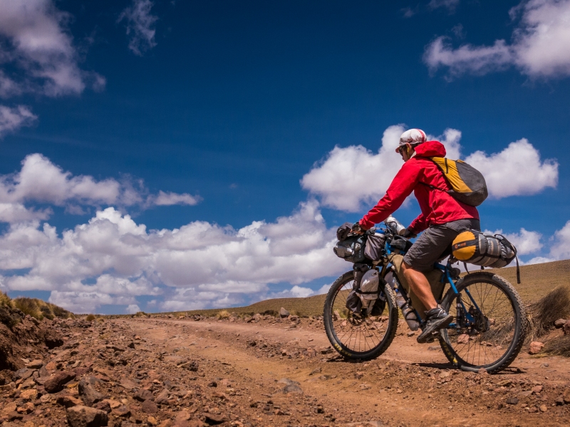
 Photo from AndesByBike, http://www.andesbybike.com.
 One of my favorite camp spots of the trip. Nestled in a ravine leading to a river, the ravine walls form a natural windbreak. Additionally, it’s only a campsite you could use when you’re sure there’s not going to be any rain- right now in the dry season.


 Heavy rain in low-vegetation desert areas: perfect for washing away roads. Bridges around here are likely pretty low down on Bolivia’s list of infrastructure priorities. Perfect place to be riding a bike.
 Look up, see dark clouds forming and lightning striking in the distance. Should you be worried about rain? No, everything will evaporate before hitting the ground. But if the skies get dark, the wind soon start.
 Altiplano road shots collection.


 Roadsigns, pre-gigantic highway size standardization.
 Animals of the altiplano: the guanaco.
 Llamas, alpacas.
 And the rhea.
 The Day of the Triple Pass, #1.
 #2.
#2.
 #3!
#3!
 Looking down towards Laguna Morijon. More lakes to come.
Thanks to the Pikes for putting together this route south from Uyuni.

Beautiful Breathtaking photos!
Too bad locals stopped eating vegetables so that we can eat healthy.
Just a little bit sobering… one more reason to support your local farmer’s market?
i freakin love your picture taking skills sam… i really want to make each one of them my wallpaper (: glad to hear from you bro. hope all is well
Woo thanks bro! Thinking back to meeting up last year in Houston… see you again in a few more months!
your pics are getting more and more artsy :):) very cool – glad to hear you are doing well – looking forward to our next skype in a week or two!
So glad I found this blog – it offers a totally different take on many of the places that my wife and I visited in a far more traditionally tourist fashion.
http://loveschneeps.com/2015/02/20/san-pedro-de-atacama/
Thanks for reading, enjoy your travels!